Listen to a special audio message from Bill Roper to the Hive Workshop community (Bill is a former Vice President of Blizzard Entertainment, Producer, Designer, Musician, Voice Actor) 🔗Click here to hear his message!
Yesterday, I downloaded the miscdata.txt and put it in a UI folder in my warcraft III directory, as I wanted to make huge cliffs with the "raise" and "lower" brushes.
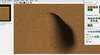
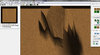
However, I found an extremely ODD glitch when I raise the terrain. When I raise the terrain only a bit, it looks good (picture 01). However, if I keep raising the terrain, a horrible glitch appears (picture 02).
This is really devastating. What can I do? I really need to make huge cliffs!
Blizzard cliffs are ugly. Very ugly.
Your idea would help me if I liked ugly things. If I use Blizzard cliffs in my proyect, well... THAT would be very odd.
And it's impossible that the glitch it's because the terrain is too big, because I have seen cliffs much more bigger than this. I will search for examples if you don't believe me.
I'm sorry, I know that you're trying to help, but I don't think that's the reason for the glitch. Anyway, thanks for answering.
You silly, you be thinkin in only the positive direction mon, you be need to lower da area around de mountains to make de mountain look bigger, mon.
Basically, just lower every other area of the map, and it would make your existing hill look alot bigger. That's all you can do. WAR3 engine limitations for the win
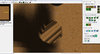
Okay, look the picture 03 I attached here. That's what I get if I lower the terrain. slash, I tested your proposition and saw this... Now I am even more convinced: this has to be a "bug". Maybe I'm wrong, but I doubt WC3 engine makes this odd glitchs. I want to solve it (if it's possible).
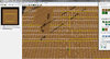
Look also at picture 04. That's what was left when I restored the terrain to the original height. The grid seems to be "broken" in some places! And a bunch of strange lines were scattered around.
This began to happen when I put the miscdata.txt file into the warcraft 3 directory. Yes, of course I could delete it, and the problem would dissappear... but then I would not be able to make infinite cliffs. And I need those cliffs.
This kind of effect is what I want for my proyect. I heard that the miscdata.txt file not only allows the creation of near infinite height cliffs, it also allows 90 degrees slopes.
If someone knows any other way to achieve this, please tell me. This problem is stopping any kind of advance in my proyect.
Thanks in advance.
Okay, look the picture 03 I attached here. That's what I get if I lower the terrain. slash, I tested your proposition and saw this... Now I am even more convinced: this has to be a "bug". Maybe I'm wrong, but I doubt WC3 engine makes this odd glitchs. I want to solve it (if it's possible).
Look also at picture 04. That's what was left when I restored the terrain to the original height. The grid seems to be "broken" in some places! And a bunch of strange lines were scattered around.
This began to happen when I put the miscdata.txt file into the warcraft 3 directory. Yes, of course I could delete it, and the problem would dissappear... but then I would not be able to make infinite cliffs. And I need those cliffs.
This kind of effect is what I want for my proyect. I heard that the miscdata.txt file not only allows the creation of near infinite height cliffs, it also allows 90 degrees slopes.
If someone knows any other way to achieve this, please tell me. This problem is stopping any kind of advance in my proyect.
Thanks in advance.
No it does not. Here, I quoted the description for you:
WE Unlimited is a simple executable file that adds additional power to
the Warcraft III World Editor without modifying any of the files of your
Warcraft installation. It enables map creators to do things previously
not possible and extends certain World Editor limits.
You might want to use both JNGP and WEU as they can enhance your map enourmously.
These tools are commonly used by the majority of the warcraft 3 editing community. And have improved an incredible amount of warcraft maps.
EDIT: Also, since this topic is about terraining. This link might help you out a lot: http://www.hiveworkshop.com/forums/...e-terraining-hives-terraining-section-184427/
The reason why you have this issue can be due to a faulty configuration of the miscdata.txt. Where did you download it from? I suggest replacing it with the one that can be downloaded in the link above ^
It's nice to see detailed answers!
It looks that the problem was not because of my MiscData.txt file. I downloaded the one in the thread you said, but it just keeps making the same horrible glitch.
I'll give a try to the WEU. For what I can see, it seems to be fairly reliable. I'll post the results, maybe tomorrow, or so. I hope the WEU won't give me this troubles...
Anyway, thank you very much.
Are you sure you aren't looking for the plateau tool? Just check the terrain palette, and select "plateau". It will create sharp edges but you can use the smooth tool on it to make really steep cliffs.
The plateau tool doesn't make the effect I want. I need vertical cliffs, and with the standard plateau brush I can't make vertical cliffs, only smooth and mound-like ones.
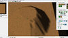
Look carefully at the image, at the red circle; look at that cliff... it's vertical. Almost 90 degrees. And it's really high.
In the video, look carefully to the inclination of the cliffs too, and you'll see that they are almost vertical.
Check the picture I attached here. Maybe your can do something better, but that's the best thing I'm able to do with the standard plateau tool. It's not vertical.
Maybe I'm wrong, maybe I don't know how to use the plateau tool and all this thread is a nonsense... but for now, I'm not able to make vertical and huge cliffs with the standard tools.
Check it out at 0:10-0:15, he is using the plateau tool that way. You gotta extend it to the edges of the hill and try not to oversmooth otherwise you will lose that steep-cliff effect.
You should know that glitch if you readed my tutorial on bad terrains it is simple it is due to the fact warcraft 3 use reals for terrains heights and so under minimal height or over maximal height the real of the height of the terrain become screwed.
use the smooth tool, it makes plateau better, plus makes it more vertical-like, sort of.
or rather use raise then plateau and smooth it up..? that's what i do.
Sorry for bringing this up again but, please be reminded that there is always a limit.
May it be extremely high or not, there always is.
I have tried doing this same thing and at some point when you raise your terrain to an extreme amount it will start bugging.
(For me, the actual grid of my terrain got removed for specific parts raised too high).
This is also what probably happened for the OP.
Which I'll explain underneath.
What PurgeandFire111 tried to explain is that you need to use the plateau tool in order to expand risen terrain to become a flat surface which you can then build from.
Usually this is done by taking the plateau tool with nothing more then one square, click on the risen terrain that you want to expand and drag it along your terrain in order to make a flat surfaced cliff.
However the problem of the OP is as followed:
Do you see that second picture he attached in the first post?
It was risen by using a medium sized circular selection.
He did not raise 1 square of his terrain at a time in order to expand it with the plateau tool.
Since the OP wanted to have a good looking cliff he kept raising to a higher level untill he did reach the actual limit
(Which removes the grid of your terrain, test it out yourself if you don't beleave me. I've done this myself several times so far).
Which causes the terrain that where off limit to be removed since the grid does not exist for that specific location.
If the OP was to turn on his grid view he would recognize the problem by seeing that the hill is now actually cut off on squares that where to high, hence you see the gap in the middle of the hill.
This can not be avoided by extending your limits with Miscdata.txt (There will still be a limit as explained above...)
I hope this was helpfull for future terraining.
Basically: Don't go way to high. Also, try raising just one square so that you can expand it with the plateau tool in order to make good looking cliffs like in the video.
No, the height limitation should be higher then it was before. It got extended (Unless ofcourse you already had the miscdata.txt). However there still is a limitation.
Even with miscdata.txt or WEU as they both extend the height of slopes to the same maximum amount.
Perhaps you might want to take a look at your cliff level to see if you have the initial height of your map on a high level or not.
If the limitation is not high enough to your needs, then you might want to start off with a lower cliff level in order to make higher cliffs.
Sorry for this late respond by the way.
Please don't stop reading at this point since this might become interesting to you.
To show you exactly what this bug does and what we can do with it I've re-created your scenario:
In this picture I created a new terrain with a cliff level of 31 (the highest initial cliff level possible).
Then I raised a slope using the medium circle sized brush.
On a certain point the grid got removed (actually, it doesn't get removed but I'll show you what happens in the Grid Reset screenshot)
As you can see in the following screenshot I have used the plateau tool to make the cliff flat again.
Now on this screenshot you can see that some parts of the cliff where to high for the map to handle.
So what happened? The grid that was to high for the editor to handle got reset to the lowest cliff level (cliff level 1).
Now here comes the usefull part! As you can see in the previous screenshot the parts that got reset are single square grids right?
However, (now pay attention) since only single points of a square grid where to high, those points of the square can not be altered (risen, lowered, smoothed, etc) anymore.
The rest of the points of the square can still be changed! This bug can be used to exploit your terrain in a very odd way...
I haven't tried using it in my advantage yet, but there might be someone who already did. I haven't gone into depth on this bug yet, so I'm uncertain of any side effects.
Use it on your own risk.
Here is an example of what can be accomplished:
As you can see this has potential...
This bug is also being used by terraining pro's to create "90 degrees slopes"
(Usually they use WEU since the advantage of this bug is integrated into WEU. Which I b.t.w. did not use on the example screenshots.)
Hint: If you've read this post carefully you should now be abled to create your own 90 degrees slopes
If not, read this part again:
Now here comes the usefull part! As you can see in the previous screenshot the parts that got reset are single square grids right?
However, (now pay attention) since only single points of a square grid where to high, those points of the square can not be altered (risen, lowered, smoothed, etc) anymore.
The rest of the points of the square can still be changed! This bug can be used to exploit your terrain in a very odd way...
I haven't tried using it in my advantage yet, but there might be someone who already did. I haven't gone into depth on this bug yet, so I'm uncertain of any side effects.
Use it on your own risk.
EDIT: Does anyone think I should create a more in-depth tutorial on creating 90 degrees slopes or has this already been done before?
I couldn't really find an explanation on how to do this anywhere and had to figure this out on my own :/
This site uses cookies to help personalise content, tailor your experience and to keep you logged in if you register.
By continuing to use this site, you are consenting to our use of cookies.


")


 Without WEU, MiscData.txt, etc...? I am not. Did you try yourself to do it? Seriously, I am unable to do so!


