• Listen to a special audio message from Bill Roper to the Hive Workshop community (Bill is a former Vice President of Blizzard Entertainment, Producer, Designer, Musician, Voice Actor) 🔗Click here to hear his message!
  • Read Evilhog's interview with Gregory Alper, the original composer of the music for WarCraft: Orcs & Humans 🔗Click here to read the full interview.

Getting Rid of a Square River Edge

Status
Not open for further replies.
Level 9
Joined
Jul 8, 2013
Messages
249
A peculiar problem has popped up in a map I'd been nearly finished with: a patch of my terrain that had looked fine before now has a bizarre, square corner in it.

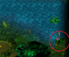
I've attached a picture of the offending area.

I want to turn that ugly, square river bank back into a smooth one but neither the Lower nor the Smooth tool in the terrain palette has any effect on it. Heck, even stuff like applying cliffs to the area just to see what happens only spreads the messed up zone.
 

Attachments

  • Terrain Problem Picture.PNG
    Terrain Problem Picture.PNG
    567.8 KB · Views: 153
Level 30
Joined
Mar 9, 2012
Messages
1,557
I cant count you how many times that has happent to me.
Sadly i dont know a fixed solution for it, mostly end up placing an large doodad that would camouflage the fault.
Its terrible when that bug-out happens with an large body of water(like in the middle of sea for no apparent reason), had to scrap an otherwise Ok map because of that.
The only real advice here is to save often and have atleast 2 files, so when that shit happens you can rollback to one previous that doesnt have it. Be careful as it may persist on happening at the same spot at a later try, if i only knew what exactly is causing it...
 
Level 14
Joined
Nov 17, 2010
Messages
1,266
You have to work with ticking "enforce water height limits" in the advanced menu and using the deep water brush on the terrain palette. After you add deep water you will want to untick enforce water limits and use the Increase two brush on the terrain palette. This should cover that area with land again and now you can use the raise and lower brushes to make it look the way you want. It is a real pain in the butt but it should work.

Make sure you have the right cliff type selected so it doesn't act funny. Good luck. It may cause you to redo a small portion of terrain but it will be better than the way it looks now.
 
Typical problem: your water information is not painted across the entire map.

A simple fix to this is by copy and pasting terrain information.
Simply draw a box in the terrain editor over a water plane. Then copy and paste it to the corner that is buggy. Of course you have to readjust the tile and elevation there, but it will fix the water map.
 
Level 9
Joined
Jul 8, 2013
Messages
249
Typical problem: your water information is not painted across the entire map.

A simple fix to this is by copy and pasting terrain information.
Simply draw a box in the terrain editor over a water plane. Then copy and paste it to the corner that is buggy. Of course you have to readjust the tile and elevation there, but it will fix the water map.

I'm not sure what you mean by "water information is not painted across the entire map", but this worked very nicely.
 
I'm not sure what you mean by "water information is not painted across the entire map", but this worked very nicely.
The water information in your map is basicly a 16-color-greyscale image with the different shades being the water level.

Since you can have the same terrain elevation with or without water (lower cliff level vs shallow water cliff), the map may have places with and without water information there.
You just reached a place there where you never used a shallow or deep water tool to paint the water map. This leads to these annoying bugs (hence why it's a good strategy to set the basic cliff level to shallow water when creating the map, so that the entire map will have a uniform water layer).

What you do by copy & pasting the terrain internally is basicly copying all terrain information "images" in the map MPQ, including the water map. This can be used to "repair" a bugged water layer locally.
 

Dr Super Good

Spell Reviewer
Level 64
Joined
Jan 18, 2005
Messages
27,286
The water information in your map is basicly a 16-color-greyscale image with the different shades being the water level.
Water is a 14 bit grey scale image with the magnitude of colour representing the height of the water mesh node. This means that there are 16,384 unique water levels. Mechanically they are the same as ground mesh levels before cliff level offset is applied.

Examples here. WorldEdit should have had similar deformation tools for water as it did for ground but I guess lazy developers are to blame.

The visibility of the water mesh layer is controlled the node flags. If water mesh visibility is set off then the water mesh will be invisible at the terrain node. The effect the water mesh has on targeting overlays will still be visible allowing for some interesting hidden terrain features.

My solution to this kind of problem is to procedurally activate the water mesh lay at every single node. Here is an example of a procedurally generated terrain that is not possible to make using World Edit.
 
Status
Not open for further replies.
Top