Zwiebelchen
Hosted Project GR
- Joined
- Sep 17, 2009
- Messages
- 7,234
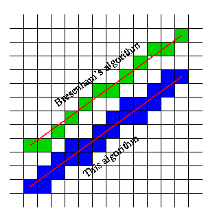
I was sick of not having a robust IsPathWalkable function that actually checks on a cell-by-cell basis, so I wrote my own based on the Bresenham algorithm of pixel graphics, which is a bit faster than one that uses trigonometry and lots of divisions and multiplications.
I think this should be the go-to for any missile or knockback system, simply because it doesn't care about the missile/unit movement speed and never skips a cell (also, it can be used to check a pathing before the unit actually starts moving, which greatly improves performance of these systems). As it always "centers" on every cell it checks, it also fixes some nasty problems with the IsTerrainWalkable resource when called on a coordinate way off the center of a cell.
Also, it returns a location of the closest pathable point.
If you want even higher accuracy (or use custom pathing maps that make use of the 32x32 grid), then you can reduce the cell size to 32.
JASS:
library IsPathWalkable initializer init uses TerrainPathability // v1.0
//get it here: [url]http://www.wc3c.net/showthread.php?t=103862[/url]

/*
 Description:
 This snippet uses the Bresenham algorithm of Pixelgraphics to check if the direct path between two cells (as a straight line) is walkable or not. It does so by looping through each cell between the two coordinates and checking their respective pathabilities.

 Note: This snippet will ignore the collision of units, but will consider all doodad, destructable or terrain pathing. If you want to consider unit collision aswell, simply swap out TerrainPathability for your desired resource and replace all IsTerrainWalkable calls in the script.


 Configurables:
 private constant boolean DIAGONAL_SAFETY
 - determines if on any diagonal step an adjacent cell is checked for extra safety (since units can not pass between two diagonally blocked cells). Default: enabled (true)
 private constant integer MIN_CELL_SIZE
 - determines the cell size for the Bresenham algorithm. As default pathing textures have a minimum cell size of 64, lowering this to 32 only makes sense if custom pathing textures are used. Default: 64.

 API:
 function IsPathWalkable takes real x1, real y1, real x2, real y2 returns boolean
 - returns true if the path between coordinates x1|y1 (start) and x2|y2 (end) is walkable

 function GetPathLastX takes nothing returns real
 function GetPathLastY takes nothing returns real
 - after using IsPathWalkable, these two functions will return the x and y coordinate of the last pathable cell between the start and end coordinate.

 */

globals
       private constant boolean DIAGONAL_SAFETY = true

       private constant integer MIN_CELL_SIZE = 64
       private constant integer CELL_CENTER_OFFSET = MIN_CELL_SIZE/2

       private real X = 0
       private real Y = 0

       private real WORLD_MIN_X = 0
       private real WORLD_MIN_Y = 0
endglobals

function IsPathWalkable takes real x1, real y1, real x2, real y2 returns boolean
       local integer xstart = R2I(x1-WORLD_MIN_X) / MIN_CELL_SIZE
       local integer xend = R2I(x2-WORLD_MIN_X) / MIN_CELL_SIZE
       local integer ystart = R2I(y1-WORLD_MIN_Y) / MIN_CELL_SIZE
       local integer yend = R2I(y2-WORLD_MIN_Y) / MIN_CELL_SIZE
       local integer dx = xend - xstart
       local integer dy = yend - ystart
       local integer adx = dx
       local integer ady = dy
       local integer sdx = 0
       local integer sdy = 0
       local integer pdx
       local integer pdy
       local integer ddx
       local integer ddy
       local integer es
       local integer el
       local integer error
       local integer x = xstart
       local integer y = ystart
       local integer i = 1
       set X = x1
       set Y = y1
       //calculate abs values and signs
       if adx < 0 then
           set adx = -adx
           set sdx = -1
       elseif adx > 0 then
           set sdx = 1
       endif
       if ady < 0 then
           set ady = -ady
           set sdy = -1
       elseif ady > 0 then
           set sdy = 1
       endif
       if adx > ady then
           set pdx = sdx
           set pdy = 0
           set es = ady
           set el = adx
       else
           set pdx = 0
           set pdy = sdy
           set es = adx
           set el = ady
       endif
       set ddx = sdx
       set ddy = sdy

       if not IsTerrainWalkable(x*MIN_CELL_SIZE+CELL_CENTER_OFFSET+WORLD_MIN_X, y*MIN_CELL_SIZE+CELL_CENTER_OFFSET+WORLD_MIN_Y) then
           return false
       endif
       set error = el/2

       loop
           exitwhen i > el
           set error = error - es
           if error < 0 then
               if DIAGONAL_SAFETY then
                   set dx = x+ddx-pdx
                   set dy = y+ddy-pdy
                   if IsTerrainWalkable(dx*MIN_CELL_SIZE+CELL_CENTER_OFFSET+WORLD_MIN_X, dy*MIN_CELL_SIZE+CELL_CENTER_OFFSET+WORLD_MIN_Y) then
                       set X = dx*MIN_CELL_SIZE+CELL_CENTER_OFFSET+WORLD_MIN_X
                       set Y = dy*MIN_CELL_SIZE+CELL_CENTER_OFFSET+WORLD_MIN_Y
                   else
                       return false
                   endif
               endif
               set error = error + el
               set x = x + ddx
               set y = y + ddy
           else
               set x = x + pdx
               set y = y + pdy
           endif
           if IsTerrainWalkable(x*MIN_CELL_SIZE+CELL_CENTER_OFFSET+WORLD_MIN_X, y*MIN_CELL_SIZE+CELL_CENTER_OFFSET+WORLD_MIN_Y) then
               set X = x*MIN_CELL_SIZE+CELL_CENTER_OFFSET+WORLD_MIN_X
               set Y = y*MIN_CELL_SIZE+CELL_CENTER_OFFSET+WORLD_MIN_Y
           else
               return false
           endif
           set i = i + 1
       endloop
       return true
endfunction

function GetPathLastX takes nothing returns real
     return X
endfunction
function GetPathLastY takes nothing returns real
     return Y
endfunction

private function init takes nothing returns nothing
    local rect r = GetWorldBounds()
    set WORLD_MIN_X = GetRectMinX(r)
    set WORLD_MIN_Y = GetRectMinY(r)
    set r = null
endfunction

endlibrary
Last edited:


")