-
Are you planning to upload your awesome map to Hive? Please review the rules here.
-
🏆 Texturing Contest #33 is OPEN! Contestants must re-texture a SD unit model found in-game (Warcraft 3 Classic), recreating the unit into a peaceful NPC version. 🔗Click here to enter!
-
It's time for the first HD Modeling Contest of 2024. Join the theme discussion for Hive's HD Modeling Contest #6! Click here to post your idea!
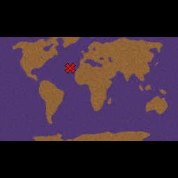
Outline Earth Template (480x288)
- Author(s)
- Emperor_Jackal
- Size
- 218.97 KB
- Rating
- Downloads
- 40
- Created
- Feb 14, 2011
- Updated
- Feb 15, 2011
- Resources
- 1
- State
 Approved
This bundle is marked as useful / simple. Simplicity is bliss, low effort and/or may contain minor bugs.
-----------------------------
Generated from http://upload.wikimedia.org/wikipedia/commons/thumb/1/19/BlankMap-World-large-noborders.png/800px-BlankMap-World-large-noborders.png using DarkLord's Terrain 1.0.
I have done nothing more than create the heightmap from the image. It is a largely featureless map, with little variation of tile heights, no variation of tiles or distribution of doodads. The use of this terrain is for the outline. Because of the relatively small dimensions (I wanted this to be fully functional on the normal world editor), the tiles merge a bit together (for example Spain has a land border with Morocco, as does Yemen and Djibouti). Some things are also a bit small, particularly in Europe, but it is all proportional. It may look a bit weird in the minimap image on this upload but that is because of the typical blurry rendering done to generate minimaps.
If you don't like a part of this world map, feel free to edit it if you plan to use it as a template. I don't care particularly for any credit either, because quite frankly more credit is deserved for DarkLord's tool, a sorely underused tool by the mapping community. Feel free to use this template however you wish.
-----------------------------
This is the 480x288 version. It still suffers from negative traits described above, albeit in a lesser form because of its increased size.

For the smaller 256x160 version, go to http://www.hiveworkshop.com/forums/maps-564/blank-outline-earth-world-template-189651/
Keywords:
World, Template, Terrain, Earth, Outline
Generated from http://upload.wikimedia.org/wikipedia/commons/thumb/1/19/BlankMap-World-large-noborders.png/800px-BlankMap-World-large-noborders.png using DarkLord's Terrain 1.0.
I have done nothing more than create the heightmap from the image. It is a largely featureless map, with little variation of tile heights, no variation of tiles or distribution of doodads. The use of this terrain is for the outline. Because of the relatively small dimensions (I wanted this to be fully functional on the normal world editor), the tiles merge a bit together (for example Spain has a land border with Morocco, as does Yemen and Djibouti). Some things are also a bit small, particularly in Europe, but it is all proportional. It may look a bit weird in the minimap image on this upload but that is because of the typical blurry rendering done to generate minimaps.
If you don't like a part of this world map, feel free to edit it if you plan to use it as a template. I don't care particularly for any credit either, because quite frankly more credit is deserved for DarkLord's tool, a sorely underused tool by the mapping community. Feel free to use this template however you wish.
-----------------------------
This is the 480x288 version. It still suffers from negative traits described above, albeit in a lesser form because of its increased size.
For the smaller 256x160 version, go to http://www.hiveworkshop.com/forums/maps-564/blank-outline-earth-world-template-189651/
Keywords:
World, Template, Terrain, Earth, Outline
Contents
Reviews

 - Second Place")


